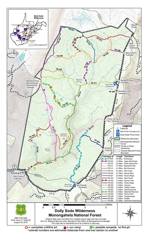
Designated Campsites in Dolly Sods
What to Know Before Hiking in Dolly Sods
- The road in is dirt and fairly rutted and full of holes and bumps. AKA: it's not great when wet.
- Wear waterproof boots (not shoes!)
- Take one of the walking sticks left at the trailhead or bring your own.
- The water is clear enough to just bring tablets or another purification system instead of your own.
- There is the occasional stack to mark the trails left by other hikers, but no proper blazes on the trails.
- You can't camp in your car at the Red Creek Trailhead, but the first designated campsite is about 300 feet away on your left hand side. The sign that says 'no bikes' is the halfway point from the car park to the first camp.
- When you cross the first stream on TR514, keep your eyes on the ground. If you make it to a campsite within about 100 feet, you've gone off the trail. Turn back around and within about ten feet there's a giant arrow on the ground made out of rocks pointing to a stack. That's the right trail.
- River crossings at the forks of TR514 & TR513 and TR514 & TR552 require getting your feet wet (no bridge) even during the 'dry' season. When we went in November, the water was maybe 1.5 feet deep and it's ICE cold.
- TR 553 is VERY wet. Some parts of the path were about 1 feet deep in mud, but the scenery is very different from the other trails and thus a walk I'd definitely recommend.
Multi-day Hikes in Dolly Sod
2 Day Hikes in Dolly Sods
- [10 MILES] Start at Red Creek Trailhead, following path TR514. The path is easily followed up to a small creek. Cross it to the much smaller path on the other side and follow it right. Keep your eyes peeled for a giant stone arrow pointing off to the right; there is a stack to mark the trail. Follow this until you see TR554 on your left (if you got lost, you would've gone straight through the campsite previously mentioned and walked along the edge of the river past all of the other campsites and their stacks; you would have eventually come to an awesome looking one with four stone-back seats surrounding a ring; TR552 is just past this on your left-hand side. If you head away from the river for about 100 feet, you'll see the proper path - if you don't, just turn back and follow the river's edge. You'll eventually run into a sign for TR514 and TR513; stay on TR514). There is a bit of relatively level ground right across from the intersection; you can camp here but there isn't a fire pit and you're not allowed to make one. The next designated campsite that I know of is a further 3.5 miles away on TR558, but I wouldn't be surprised if you passed a designated campsite (ie: with a fire pit) on TR514 just seconds before. If not, the clearing is about maybe two tents wide so you'll have plenty of privacy through the night. Carry on TR554, take a right onto TR513 and within about 1/2 mile cross the stream to TR558 on your left-hand side. Stay on this trail, which will eventually change name to TR552. WET FEET RIVER CROSSING AHEAD!!! Cross the river, dry off, and then take a right onto TR514. (This intersection would be very familiar to those of you who got lost at the start. :P) PATH SUMMARY: TR514 -> TR554 -> TR513 -> TR558 -> TR552 -> TR514
- [16 MILES] Start at Red Creek Trailhead. Grab one of the walking sticks left by the sign if you don't have your own and head in on TR514. The path is easily followed up to a small creek. Cross it to the much smaller path on the other side and follow it right. Keep your eyes peeled for a giant stone arrow pointing off to the right; there is a stack to mark the trail. Follow this until you get to TR513 (if you got lost, you would've gone straight through the campsite previously mentioned and walked along the edge of the river past all of the other campsites and their stacks; you would have eventually come to an awesome looking one with four stone-back seats surrounding a ring; TR552 is just past this on your left-hand side. You're about halfway there to TR513 so just keep staying along the riverside). WET FEET RIVER CROSSING AHEAD!!! Cross the river, dry out on the rocks, and carry on. This path is fairly steep, but not too bad. If you're quiet you might even see some deer like we did. Turn off onto TR554. Less than a mile into it, you'll come across a giant pile of white rocks on your left. The view's quite nice at the top if you're able to do a scramble. Follow the path to the end of TR554 and take a left onto TR514. Carry on for about 1.7 miles and then take a left onto TR553. The trail is fairly wet and muddy, but the scenery changes dramatically. It's the 'Canada-like' look you might've already read about. I've yet to go to Canada so I can't say whether or not that's true, but it is the prettiest section in Dolly Sods imo. There are some designated camps along TR553, but when we were there at the start of November 2015 there wasn't any water alongside them so if you haven't brought your own, then you'll have to carry on until the end of the path and then maybe half a mile further. Camping at the blue dot marked campsite on TR513 (it'll be on your left; see map above) will mean you've now walked about 9.6 miles. Only roughly 6 more to go! Follow TR513 down for about one mile. You'll come to a 'Y' section where the left one branches off into a meadow and the other follows the trees across a little stream. Take the one across a stream and you'll eventually come to a sparsely packed wooded area. Keep your eyes open for the stacks and follow it to TR558. This trail is a bit harder to find as more than likely you'll end up off of TR558. Don't worry; this is okay. All you would have done was cross the river before you were 'supposed to.' Either way you'll have to cross it before you see the sign for TR558 on your right. Stay on it and it'll change name to TR552. Follow it to the river where there will be another WET FEET RIVER CROSSING!!! Cross the river, dry off, and then take a right onto TR514. PATH SUMMARY: TR514 -> TR513 -> TR554 -> TR514 -> TR553 -> TR513 -> TR558 -> TR552 -> TR514
Do you know of any free designated campsites in Dolly Sods that we haven't covered? Have you slept without any trouble at one of the green circles (the possible sites)?